Get to know the photo book "The Most Beautiful Trails of Patagonia"
Torres del Paine, El Chaltén, Bariloche, Ushuaia, Villarrica, Cerro Castillo, Dientes de Navarino and Parque Patagonia
Paddling around Ilhabela, Brazil – Itinerary and tips
Attention: The goal of this article is only to help you with the logistics of your trip around Ilhabela. You should not imagine that by reading what is written here, you will be prepared to paddle in a self-sufficient way. If you and the other people of your group have never done a kayak trip, go with more experienced paddlers. It will do no good if you have all the theory if, in practice, you don’t know what to do if the sea get rough when you are on the open sea. The big difference from a kayak trip to a bicycle trip or a multi-day hike is that, in land, if the weather changes in a moment, we can sit down and wait for the weather to improve. At sea this doesn’t work so don’t be a fool, there are already plenty of risks even for those who know what they are doing.
Overview
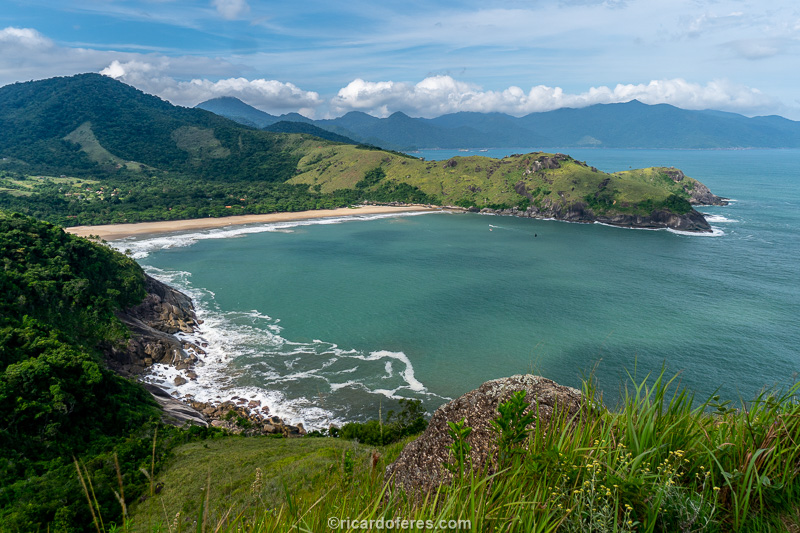
The Ilhabela circumnavigation is one of the classic Brazilian paddling trips and it is, for sure, one of the most beautiful. Located just 200 km from São Paulo and 430 km from Rio de Janeiro, Ilhabela is part of Costa Verde (Green Coast), a stunning area with beaches surrounded by mountains and a rain forest called Mata Atlântica.

The total distance of the trip is approximately 115 km (71 mi) and, to get to know the most beautiful points, the ideal is to make it in 4 days. But if you are very fit and want to spend just a little time on the beaches, it is feasible to do it in 3 days.
Below are, in my opinion, the best overnight places, main attractions and the distance between them, so you can plan according to how many days you have and the starting/ending point.
Starting point
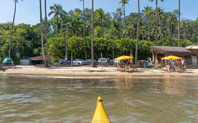
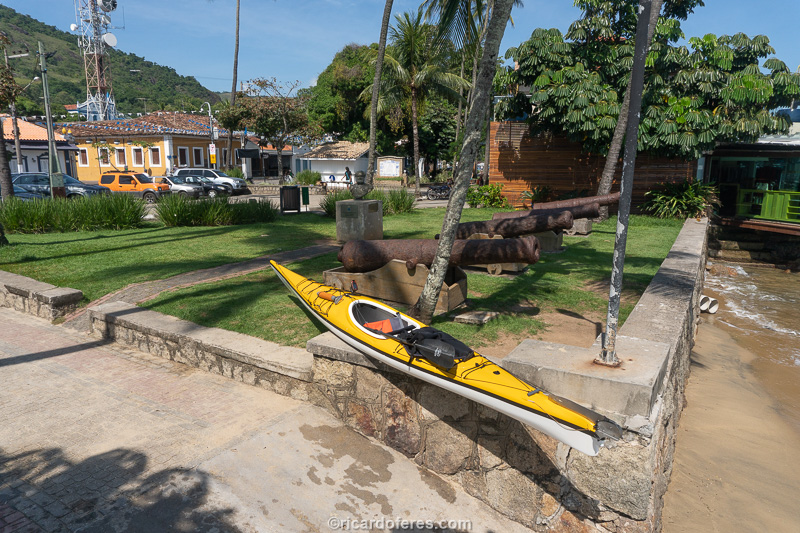
– Preta do Centro Beach (São Sebastião): As I live in São Sebastião, I always start at Preta Beach. This is the place where the channel is narrower, with only 2 km (1.3 mi), so it will not change a lot the total distance. Even for tourists, I consider it the best option because you avoid the ferry with its usual queue. In addition, it is allowed to drive on the beach to unload. As there are two beaches with the same name in São Sebastião, make sure that the GPS is taking you to Praia Preta do Centro, not to Praia Preta da Costa Sul.
– Perequê Beach: In the central region of Ilhabela, the best place to put the kayak in the water is the public ramp at the southern end of Perequê Beach. Starting in the central region, you will split better the distances between the first and the last day.
– Veloso Beach: If you want to start in the south of the island, Veloso Beach is the last and the car gets very close to the water.
– Sino Beach: If you want to start in the north of the island, Sino Beach is the most northerly beach where the car gets close to the water.
Clockwise or counterclockwise?
The most dangerous section of the trip is from Ponta do Boi to Ponta da Piraçununga, so I prefer to do it counterclockwise, passing through the most exposed section at the beginning of the second day. However, if the weather and sea forecast is better to do it clockwise, be smart and take advantage of the sea/wind condition.
If you don’t know how to check the weather and wave forecasts to decide which is the best way to do the circuit, don’t get me wrong but you are still not ready to go to the sea in a self-sufficient way, go back to the first paragraph and read it carefully.
How many days?
For those who have never been in Ilhabela, I recommend that you do it in 4 days, so you will have time to stop on several beaches, spend some time diving and even doing trails that lead to viewpoints and waterfalls. Doing it in 4 days, the best overnight places are:
1st night = Bonete Beach (organized camping or inn);
2nd night = Figueira Beach (wild camping) or Castelhanos Beach (organized camping or Airbnb);
3rd night = Caveira Beach (wild camping) or Poço Beach (wild camping).
If you prefer to do it in 3 days, the overnight places are:
1st night = Bonete Beach (organized camping or inn);
2nd night = Caveira Beach (wild camping).
Another option, for those who doesn’t want to sleep in tents, is to do the overnights only at Bonete and Castelhanos. On these beaches there are organized campsites, inns and restaurants, making life easier for those who do not enjoy wild camping. The problem is the distance from Castelhanos to São Sebastião Channel, where you can finish your trip, but if you want to stop at Sino Beach, it is only 35 km (22 mi).
Itinerary
As it is explained in the topic ‘Starting point’, there are several beaches that can be used to start your trip. As my favorite place is Preta do Centro Beach (São Sebastião), I will use it to describe the itinerary but you can easily adapt it to the location you choose, just adapting the distances.
I will describe the trip in counterclockwise direction for the reasons that I have already explained. The distance in parentheses is always related to the start of the trip at Preta do Centro Beach.
Cabras Island (2 km / 1.2 mi)
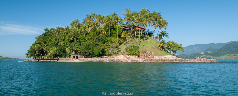
Leave Preta Beach towards Cabras Island. The island is private and has no beach, but that is not a problem as the most interesting is underwater. That’s because the waters around the island belong to a Marine Sanctuary created in 1992, protecting the fauna and making possible, if the water is crystal clear, to see many fish even from the kayak.
Feiticeira Beach (4.5 km / 2.8 mi)

The next beach that deserves to be mentioned is Feiticeira, which on its right side (from the sea to the beach) has a colonial style house that, until the 1970s, was the headquarters of a sugar cane farm and production of liquor. Now the house is used only for parties.
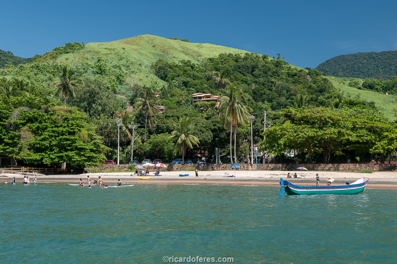
Curral Beach (8.5 km / 5.3 mi)
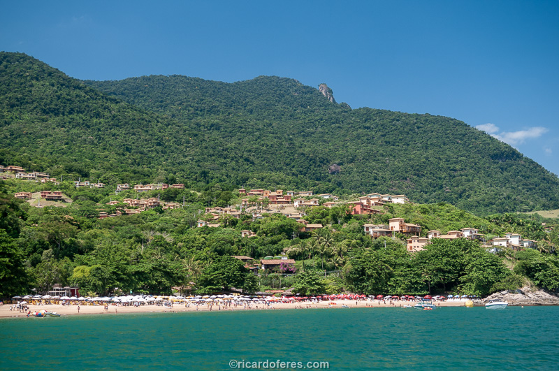
With many hotels, restaurants and bars with loud music, Curral is one of the most famous beaches in Ilhabela and, for that reason, it is not one of my favorites. But due to its fame, I cannot fail to quote it in this article.
Veloso Beach (9 km / 5.6 mi) – Alternative starting/ending point
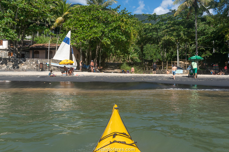
Next to Curral Beach, Veloso is the last beach inside the São Sebastião Channel. Much more peaceful than its neighbor, it is your last chance to land on a beach before heading to Bonete, 21 km (13 mi) later. It is also one of the good starting points for this trip, in case you decide to leave from Ilhabela, not São Sebastião.
Sela Point (12.5 km / 7.7 mi)
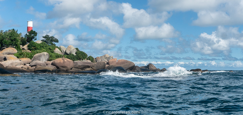
Sela Point and its lighthouse mark the end of São Sebastião Channel and the beginning of the paddling in the open sea, with less influence from the tidal current, which is usually strong in the channel.
Cação Hole (22 km / 13.7 mi)

To show you the size of this cliff, I made a red circle around where I was standing.
Cação Hole and Oratório Cave are two beautiful formations that, with a completely flat sea, allow a visit. When I say completely flat sea, it is not an exaggeration because the waves that are small on the outside, grow within the caverns and throw the kayak against the rocks. I know of at least one death in that place, so my tip is to look it only from the outside.
Bonete Beach (29.5 km / 18.3 mi) – Overnight place

Among the beaches with access only by sea or hiking, Bonete is the most famous and it deserves the fame. The old fishing village now has some inns, campgrounds and restaurants, but still has not lost its charm and is home to the largest traditional fisherman community of Ilhabela.
With more than 600 meters, it is also famous among surfers, especially the left side (looking from the sea to the beach), known as Canto do Surf. It is on this side that the campground Outro Canto is located, right in front of the beach, but if the sea is rough and you are not safe to land there, go to the other side, known as Canto do Rio, because the waves are usually smaller there.
After settling in, if you still have time and energy, go up to one of the lookouts to have a beautiful view of the beach. There is one viewpoint on each side and, as the distance for them is similar, it only depends on which view you prefer to have, see the photos above and choose.
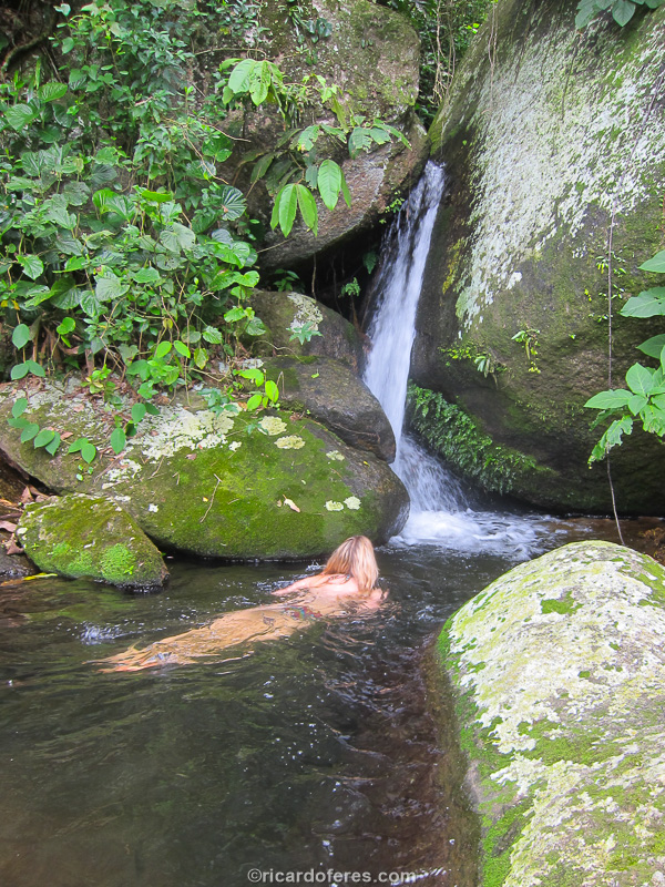
If someone recommends you the trail to the waterfall, go but know that there is no waterfall, it’s just a pond with a small rapids. Great place to cool off, I just think it’s good to warn you so you won’t be disappointed.
To eat a simple, typical and tasty dish, go to Restaurante da Izabel, a very small and rustic restaurant, with few options but with good food and fair price. The restaurant is on the way to the “waterfall”, just ask any resident how to get there.
Indaiauba Beach (35.5 km / 22 mi)
At Enxovas Bay there are 3 beaches: Bonete, Enxovas and Indaiauba. By now you have seen Bonete and, if you want to stop at another beach in this bay, stop at Indaiauba, which I think is more beautiful than Enxovas. On the left side (looking from the sea to the beach) there is a very small waterfall but it is good for cooling off and removing the salt from the body. After Indaiauba, the next beach is Codó, 23 km (14 mi) from here. If you decide to go straight from Bonete Beach to Boi Point, you will paddle 3.5 km (2.2 mi) less than coasting to Enxovas and Indaiauba.
Boi Point (45 km / 28 mi)

Boi Point is one of the most dangerous spots of the trip and, if the sea is rough, it is better to paddle far away from the coast to avoid the waves that hit the cliff and make the sea to be even worst. Boi Point lighthouse was inaugurated in 1900 and is, in my opinion, the most beautiful of Ilhabela.
Pirabura Point (49 km / 30.4 mi)
Ilhabela is the largest ship graveyard in Brazil, there are countless shipwrecks that occurred here and the most famous and deadly of all was Príncipe de Asturias. It was the most luxurious liner in Spain and made the Barcelona-Buenos Aires route, but in 1916 it crashed against Pirabura Point, causing 445 deaths. Some people say that there were many unregistered passengers in the hold of the ship and that they died without being counted, but that has never been proven.
Leaving the tragedy aside, Pirabura Point provides a shelter against south wind and swell, making it a good place for those who want to get out of the kayak for a while. As there is no beach, only do this if you are sure that you can re-enter the kayak in a deep water. Whenever I passed here, there was a big float where one can tie the kayak so it doesn’t drift, but don’t take it for granted.
Piraçununga Point (53.5 km / 33.2 mi)
This point marks the end of the most isolated section of the circumnavigation and, from now on, you will meet with other boats more frequently.
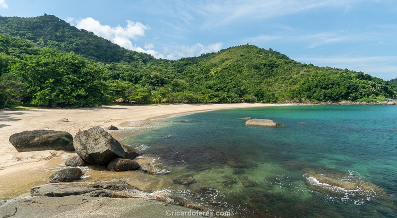
Codó Beach (58.5 km / 36.3 mi)


There are several tiny beaches in Ilhabela and many of them don’t even have a name, but the most beautiful of all has and is called Codó. In front of Galhetas Islands, in a tiny bay and with two houses on its slope, you should take care to not hit the kayak on the rocks, especially at low tide.
Figueira Beach (60 km / 37.3 mi) – Overnight place
At Figueira there are no campgrounds or inns, so you will have to do wild camping. However, before pitching your tent, talk to the residents and ask for permission. Being friendly, polite and respecting the residents, they will not deny your request. It is true that the beach is public but they live there, preserve the place and, if we take the law seriously, remember that it is forbidden to camp on Brazilian beaches. Therefore, always respect the residents, do not make noise and, most important, do not leave garbage. Of course, these rules should be followed anywhere, but, as many people do not, it is worth emphasizing.
An alternative to sleep with more structure is going to Castelhanos Beach, read the description below.
Castelhanos Beach (66 km / 41 mi) – Overnight place
The distance from Figueira to Castelhanos is small, so it is worth getting close to Vermelha and Mansa beaches to take a look at them at least from the kayak. Although they are very beautiful, they don’t have a special attraction than there are on the other beaches.
Castelhanos is one of the most beautiful beaches of Ilhabela and can be reached by a dirt road that is often in very bad condition, so it is allowed to use it only with 4WD cars. During the high season and on weekends, dozens of off road cars take tourists to Castelhanos and its restaurants. Anyway, the beach is long and not crowded, but it is still a shock compared to the beaches visited so far.
To have a beautiful view, go to Coração Lookout, on the left side (looking from the sea to the beach).
Camping do Leo is the only one I have ever used and faces the beach, on the left side (for those looking from the sea), but there are also other accommodation options, including Airbnb.
The advantage of sleeping in Castelhanos and not in Figueira is that you will already be installed to do the trail to Gato Waterfall, described below.
Gato Waterfall (5 km / 3 mi hike)
Important: right now the waterfall is closed for visitation due to the remodeling of the water supply pipes for Gato community.
The third day has less paddling hours to leave time for a visit to Gato Waterfall, one of the most beautiful waterfalls of the island. The trail to it has 5 km / 3 mi (round trip, counting from the middle of the beach) and 150 meters (500 ft) of ascent. I recommend that you go early, before the 4WD cars arrive with tourists, so you will have the waterfall without people or with just a few persons.
Eustáquio Bay (75 km / 46.6 mi)
Famous spot among motorboat and sailboat owners, in high season you will find dozens of boats attracted by the calm and crystal-clear waters of this bay and also by its restaurant, which they say is good but I have never tried it. If you think there are too many people and boats, on the left side of the bay there is a very small beach where you will find peace.
Caveira Beach (77 km / 47.8 mi) – Overnight place


Caveira is the best beach for those who like wild camping, since there are no houses, there is good space for tents and hammocks and a stream that, even though it is not deep, allows a bath to remove the salt from the body. To get fresh water, cross the stream and walk about 10 meters (30 ft) to a small rapids.
Facing east and the island of Búzios, the sunrise and the moonrise are stunning at Caveira, as well as at Castelhanos.
Riscada Beach (81 km / 50.3 mi)
Riscada has less than 50 meters (165 ft) but it is worth a quick stop. It is not very easy to see it as it is hidden by the rocks and, if you decide to stop, be careful when landing because of the rocks. Between Caveira and Riscada is Serraria Beach, which houses a caiçara (traditional fisherman) community, it is beautiful but it does not have something that stands out from other beaches.
Poço Beach (87.5 km / 54.3 mi) – Overnight place

With less than 100 meters (330 ft), it is one of the most beautiful beaches on the island because there is a rapids and a beautiful pond that is good for a swim and to hide from the black flies, which are even more voracious here than in other beaches of Ilhabela. The problem is that from time to time the waves remove the sand that dams the river or, worse, remove all the sand, making it difficult for those who want to camp.
Jabaquara Beach (93.5 km / 58.1 mi)

Among the beaches reached by a 2WD car, Jabaquara is the one I consider most beautiful. At the end of a dirt road, it has restaurants and is busy in high season. I didn’t put it as an alternative starting/ending point because the parking lot is not as close to the water as at Sino Beach, but it can also be used, just talk to Espaço Tangará restaurant in advance to ask if you can leave the car for several days.
Canas Point (99 km / 61.5 mi)
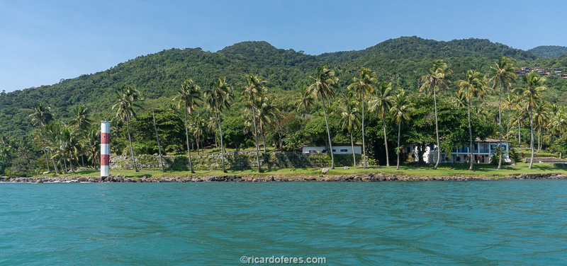
Canas Point, its lighthouse and a beautiful colonial-style house mark the re-entry into the São Sebastião Channel, with its usual strong tidal current, so don’t think “it’s over” because if the current and wind are against you, it is very likely that it will be the most tiring section of the trip. From now on you will have many beaches to stop, stretch your body and eat or drink something.
Sino Beach (102 km / 63.3 mi) – Alternative starting/ending point
Beach with good tourist structure but not as beautiful as the previous ones. The quote in this article is because it is a good place to start or end the trip because the car gets very close to the water and there are places to sleep and leave the car in safety.
Vila (105 km / 65.2 mi)
If you still haven’t been at Vila, as it is called the tourist center of Ilhabela, it is worth stopping for a walk through its charming streets, stores and restaurants. Just before the pier you will see some concrete ramps, go up there with your kayak if the tide is too high.
Perequê Beach (109 km / 67.7 mi) – Alternative starting/ending point

Perequê Beach is not beautiful, but on its left side (for those who are on land, looking at the sea) there is a public ramp, as explained in the topic “Starting point”.
Preta do Centro Beach (115 km / 71.5 mi)
To arrive at Preta do Centro Beach you can continue paddling along the coast of Ilhabela until Cabras Island or you can cross the channel and paddle under the largest oil port in Brazil, taking a look at the center of São Sebastião from the sea. If the current is in your favor, it may be a good idea to cross the channel on its widest stretch to take advantage of the little push. If it is against you, go very close to Ilhabela to avoid paddling against the current.
Get to know the photo book "The Most Beautiful Trails of Patagonia"
Torres del Paine, El Chaltén, Bariloche, Ushuaia, Villarrica, Cerro Castillo, Dientes de Navarino and Parque Patagonia