Get to know the photo book "The Most Beautiful Trails of Patagonia"
Torres del Paine, El Chaltén, Bariloche, Ushuaia, Villarrica, Cerro Castillo, Dientes de Navarino and Parque Patagonia
Mauna Kea volcano (Hawaii), the biggest cycling climb on the planet

Hilo and Mauna Kea in the background
It’s in Hawaii the biggest uphill of the world, more precisely on the Big Island, the biggest Hawaiian island. Beginning in the city of Hilo, at sea level, there are 69.2 km (43 mi) of a continuous uphill until almost reaching the summit of Mauna Kea volcano, which is 4,205 meters (13,796 feet) high. I say that it almost arrives because the road ends next to the observatories, at 4,192 meters (13,753 feet), and the summit is 13 meters (43 feet) higher but, to reach it, you have to take a small trail that has a descent, so it’s no longer a continuous climb.
First of all, it’s good to explain that this is the biggest uphill of the world, but not the longest. There is an uphill in Colombia known as Alto de Letras which has 82 km (51 mi), but with an elevation gain of 3,200 meters (10,500 feet), beginning at 500 m (1,640 ft) altitude and ending at 3,692 m (12,112 ft), so it has one thousand meters (3,280 ft) less than Mauna Kea. And as the distance is greater, the slope is lighter, making it a much less tiring uphill, despite the fact that there are some downhills on the road, not being a continuous uphill.
There are many different formulas used by cycling media to figure out the hardest climbs in the world, but in one thing they agree, that “Le Mauna Kea – Hilo”, as it’s called, is the most challenging. The reasons that lead to this are:
1. Higher ascent than any other climb;
2. Sections with a gradient over 20%;
3. One of the longest continuous climb distances;
4. Altitude: it’s much harder to climb straight up to 4,000 meters (13 thousand feet) than twice to 2,000 meters (6,500 feet), since thin air makes breathing difficult and can cause altitude sickness;
5. Above 3,000 meters (9,842 feet) there is a section with 7 km (4.3 mi) of gravel and dirt that, in some points, is very soft, making the tire to sink and the effort has to be much greater.
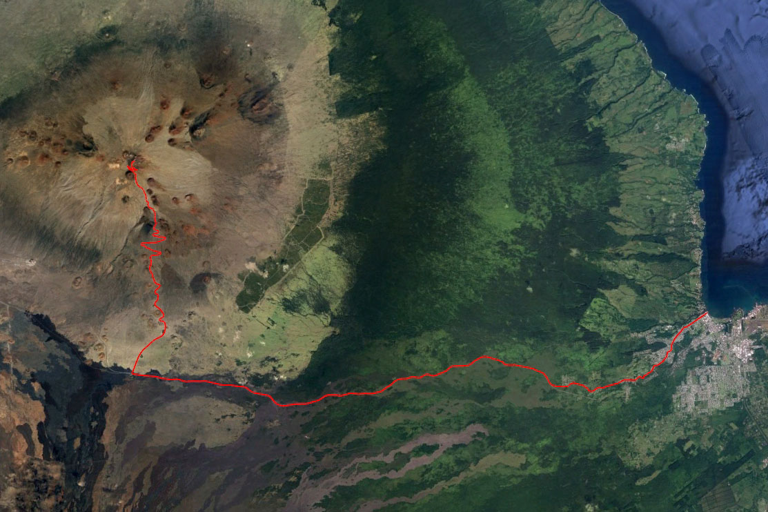
The road from east to west is Saddle Road, and from south to north is Mauna Kea Access Road
From 1 meter (3 feet) to 4,192 meters (13,753 feet) always going up
The climb
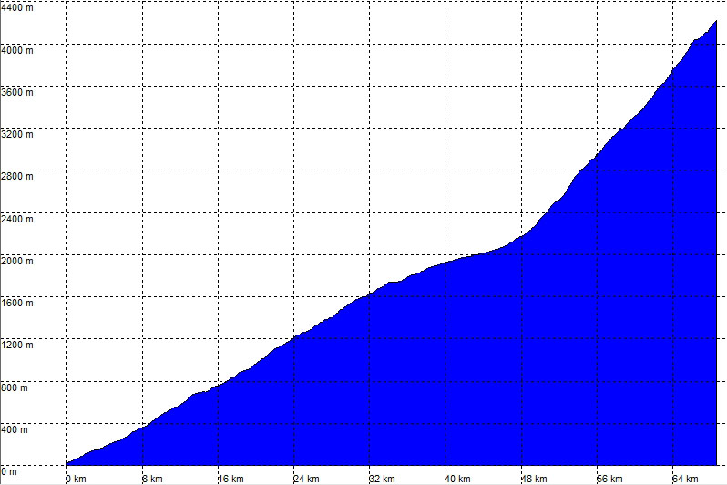
When I have a physical challenge that last many hours, I like to break it down into smaller sections so I can control better the psychological challenge. Here I split the climb in 4 stretches, and only the first two I’ve had ride before. The problem is that, in this climb, every stretch the difficulty increases, not only by the slope gradient as by the increasingly thin air and, of course, the accumulated fatigue.
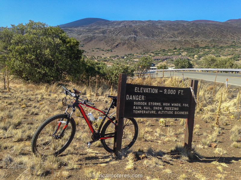
The first stretch is made on the Saddle Road and has 45 km (28 mi), until entering the Mauna Kea Access Road. With an average elevation of 4.5% I can say it’s easy for a well-trained mountain biker. The elevation goes to 2,000 meters (6,561 feet) and during the ascent is very interesting to see the changes of vegetation as the altitude increase. In the beginning there are big trees and dense vegetation, from there it gets more and more scarce until the landscape turns almost totally brown, with just little plants. The road is good and even in sections where there is no shoulder, the cars usually respect the cyclist. With the time and the steady ascent, the body became used until in some places I had the impression that I was riding in a flat road, but then, checking the altitude profile of the GPS, I saw that they were little steep ascents.
The second stretch begins when entering the Mauna Kea Access Road and the slope gets much stronger, with an average of 8%. There is 10 km (6.2 mi) of asphalt until the Visitor Information Station, at 2,800 meters (9,186 feet) of altitude. If the ride had started on this road, it would be easy to beat these 10 km (6.2 mi), but after the previous 45 km (28 mi) I can say that the challenge begins to be interesting. If you don’t have a car providing support for you, this is the only place where you can refill the water bottles and buy some food, but it’s worth saying that there are not much more than sandwiches and biscuits, so I brought all my food from Hilo. Because of a gross planning mistake, I left Hilo one hour late, which made me have to swallow the food as fast as possible to try to reach the summit before sunset. Except for an abdominal pain that I also had when I rode here doing a training, I was feeling good, with no muscular fatigue or strong pains caused by the time on the bike, so it was not a problem to shorten the stop, only my mind got messed up, as I hate to make this kind of mistake.
Arriving at the Visitor Information Station
The third stretch has 7 km (4.4 mi) and is the dream of every mountain-biker who enjoy a strong climb. The average ascent is of 10% but some stretches are above 20%! To make it even worse, there is no asphalt, only gravel or dirt and, as in many places the dirt is very soft, almost like sand, these 7 km (4.4 mi) prevent climbing with a road bike. That’s precisely why I went with a mountain bike 29er with 2.1 tires, which made me ride slower in the asphalt but allowed me to ride this part always on the bike, never pushing it. When looking for other people who made this ride, I saw that they used two bikes: a road bike from Hilo to the Visitor Information Station and a mountain bike after that. I won’t say that this is cheating, but I can say that’s not my style, I like to be self-sufficient (not having a support car) and I think it’s more rewarding to do everything with the same bike. Other cyclists used only a road bike with larger tires, pushing the bike on the soft soil stretches, but I believe that if you want to say that you beat the hardest climb in the world, you have to stay all the time on the bike.
The fourth stretch is the last one (at least!) and, like the third, has an average gradient of 10% with peaks over 20%. the difference is that this stretch is paved, but don’t think that I was able to ride faster, as the increasingly thin air and fatigue accumulated from the previous 62 km made the last 7 km the most suffering that I’ve had in all my years of mountain-biking, a truly hell! I tried not to look what was ahead and focus on the moment, but it’s difficult don’t be curious and watch that beautiful landscape, completely different from any other place that I’ve ever rode a bicycle.
As after the Visitor Information Station only 4wd cars can go, the traffic isn’t great, but even then several slowed down to ask where I came from. Usually I thought “Please let me alone, I have to breath deeply, I can’t talk”, but despite this desire of being quiet, one conversation was very interesting:
-Where did you start?
-Hilo.
-Wow! Where you are from?
-Brazil.
-Going to the summit?
-Yes.
-You are a legend!
-Thanks.
Okay, I know he was exaggerating and I’m far from being that good, but I can’t deny that it was a good incentive. And that was also a great massage in the ego, I can’t deny either, but as a little vanity helps achieve the goal, why don’t be flattered?
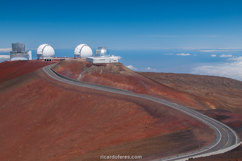
Photo taken on my previous trip to Hawaii showing the end of the road and some observatories
Even though I did few stops to stretch and I ate as fast as I could, I couldn’t reach the summit before sunset. Anyway, it was an incredible feeling to beat the hardest climb in the world without having to push the bike at any time and not having a support car carrying food, drink and warm clothes. Speaking of cold, I left Hilo with 28° C (82° F) and in the summit it was minus 2° C (28° F)!
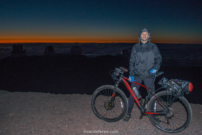
Freezing temperature in the summit
I had the idea of doing this ride when I first traveled to Hawaii, in 2010. At that time I didn’t even know it was the biggest and hardest climb in the world. It has passed 6 years before I got back to Big Island and put this fixed idea into practice, realizing it on 04/17/2016, right on my 40th birthday. And to celebrate the anniversary, my relatives who live in Hawaii went with a 4wd up to the summit and took brigadeiros (Brazilian dessert typical in birthdays) and champagne to celebrate. That’s a trully unforgettable birthday!
During the climb, in the most distressed moments, my mantra was “it’s only once in my life”. It worked, the problem is that now, while I’m writing this article and thinking about the experience, I’m starting to desire to do it again… Definitely, there is something wrong with me.
Get to know the photo book "The Most Beautiful Trails of Patagonia"
Torres del Paine, El Chaltén, Bariloche, Ushuaia, Villarrica, Cerro Castillo, Dientes de Navarino and Parque Patagonia