Get to know the photo book "The Most Beautiful Trails of Patagonia"
Torres del Paine, El Chaltén, Bariloche, Ushuaia, Villarrica, Cerro Castillo, Dientes de Navarino and Parque Patagonia
Itatiaia National Park, Brazil (Upper Part)
First Brazilian national park, Itatiaia was created in 1937 and currently covers 280 km² (108 mi²) of Mantiqueira mountain range in Rio de Janeiro and Minas Gerais states.
The park is divided in two areas, the Upper Part and the Lower Part. While the Lower Part has its most attractive waterfalls, the Upper Part, which is the area covered by this Virtual Tour, attracts visitors looking for the views of its beautiful mountains surrounded by altitude fields, a vegetation adapted to the cold of the winter, which commonly has negative temperatures.
Information on how to get to the Park, ticket values to spend the day or to spend the night in the camping or shelter Rebouças can be seen in the official page of the PNI https://pnitatiaia.com.br/loja/
Virtual Tour with 360° interactive images
Open the photos using the thumbnails below. Pictures can be rotated and the viewing angle can be zoomed in or out. Clicking on the ‘360‘ symbol opens another photo and the ‘i‘ symbol provides information about that location. Beside the text of each attraction there are also some static photos that can be seen in larger size, just click on them.
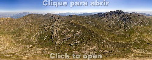
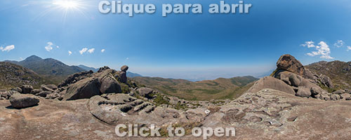
Aerial 360° image in the center of the Upper Part
Agulhas Negras

360° image at Agulhas Negras summit, fifth highest point in Brazil, with 2,791 meters (9,156 feet)
Distance and elevation (round trip) from Posto Marcão (entrance): 19 km (11.8 mi) / 460 m (1,509 ft)
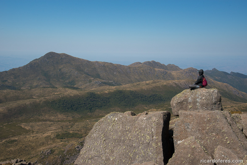
The highest point of Itatiaia is also its main attraction, as it offers views for the whole upper part. There are several climbing routes but even those who do not climb can reach the summit through a trail with places where you’ll have to use your hands too, and one or another place using ropes. If you are not a climber or a very experienced mountaineer, hire a guide so you won’t miss the day looking for the path and to prevent an accident, what is not uncommon here.

Moon over Agulhas Negras

Agulhas Negras massif

Cracks that give name to the massif

Beginning of the ascent
Asa de Hermes
360° image beside Asa de Hermes
Distance and elevation (round trip) from Rebouças Campground: 6.6 km (4.1 mi) / 290 m (951 ft)
Distance and elevation (round trip) from Posto Marcão (entrance): 12.6 km (7.8 mi) / 330 m (1,082 ft)
This trail is rarely used because the most beautiful view of the Asa de Hermes is from the trail to Agulhas Negras or Pedra do Altar, not being next to it. Anyway, it’s a very fun trail, crawling under stones and short climbing stretches, but since it’s a poorly marked path, it’s important to be with a guide.

Asa de Hermes in the morning

Asa de Hermes

Trail do Asa de Hermes

Passage under the rocks on the way to Asa de Hermes
Flores waterfall

360° image of Flores waterfall
Distance and elevation (round trip) from Posto Marcão (entrance): 6 km (3.7 mi) / 100 m (328 ft)
Being the shortest trail in the Upper Part and in the way of those who go to Prateleiras, this small but beautiful waterfall can receive a lot of people on weekends, even with its incredibly cold water.

Flores waterfall and Milky Way

Flores waterfall
Aiuruoca waterfall

360° image of Aiuruoca waterfall
Distance and elevation (round trip) using Cinco Lagos Circuit: 12,2 km (7.5 mi) / 350 m (1,148 ft)
The waterfall is beautiful, but depending on the season may have small volume of water. Even in the summer the water is extremely cold, indeed even colder than Flores waterfall. In one of the measurements I made in October 2015, the thermometer marked only 7° Celsius (44° Fahrenheit), so think twice if you want to do this trail to swim in these waters.

Aerial photo of Aiuruoca waterfall

Underwater photo of Aiuruoca waterfall

Aiuruoca waterfall

Trail to Aiuruoca waterfall
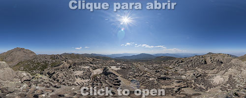
Morro do Couto and Couto-Prateleiras Crossing

360° image at Morro do Couto, 8 highest Brazilian point with 2,680 m (8,792 ft)
Distance and elevation of Couto-Prateleiras Crossing: 13.2 km (8.2 mi) / 820 m (2,690 ft)
Morro do Couto is on the edge of the Upper Part and has a beautiful view both inside and outside the Park, to Serra Fina and Pedra da Mina, the fourth highest point in Brazil. The summit of Morro do Couto can be reached by a trail that starts at Posto Marcão (entrance) or by doing the circuit that crosses Morro do Couto and goes to the base of Prateleiras, returning by Flores waterfall and Rebouças Campground, which I consider the best option.
Aerial photo of Morro do Couto

Pedra da Mina seen from Morro do Couto

Toca do Indio

Prateleiras seen from Morro do Couto
Ovos da Galinha
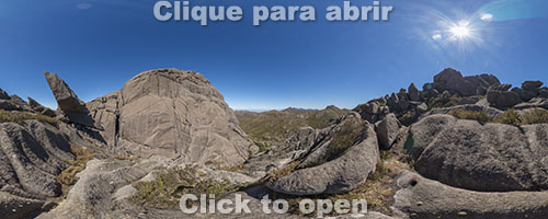
360° image of Ovos da Galinha
Distance and elevation (round trip) using 5 Lagos Circuit: 14 km (8.7 mi) / 580 m (1,902 ft)
Ovos da Galinha (Chicken Eggs) are very interesting formations and it’s worth seeing them when you go to Pedra do Sino, since they are on the way, or when you go to Aiuruoca waterfall, as it’s not far from them.

Ovos da Galinha

Ovos da Galinha seen from Pedra do Sino
Pedra do Altar

360° image of the eleventh highest point in Brazil, with 2,665 metros (8,743 feet)

360° night image of the eleventh highest point in Brazil, with 2,665 metros (8,743 feet)
Distance and elevation using 5 Lagos Circuit to go and going back via Rebouças Campground: 11,2 km (6.9 mi) / 400 m (1,312 ft)
Pedra do Altar (Altar Rock) is right in the center of the Upper Part, providing an exceptional view to almost all attractions, such as Agulhas Negras, Prateleiras, Morro do Couto, Asa de Hermes and Pedra do Sino. The short trail is well marked and is one of my favorites places in the Park.

Sunrise and Agulhas Negras seen from Pedra do Altar

Milky Way seen from Pedra do Altar

Pedra do Altar and moon

Prateleiras and Morro do Couto seen from Pedra do Altar
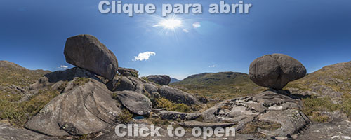
Pedra Assentada
360° image of Pedra Assentada, at 2.453 meters (8,048 feet)
360° aerial image on the way to Pedra Assentada
Distance and elevation (round trip) from Posto Marcão (entrance): 14.4 km (8.9 mi) / 330 m (1,082 ft)
Most people (guides included) think that Pedra Assentada is in the Prateleiras massif and can be seen from Pedra da Maçã. But no, this is not Pedra Assentada, the real one lies in another massif to the east, on the edge of the Upper Part. As the path is very badly marked from the point where the massive begins to rise, I recommend that you hire a guide not to lose your day or, worse still, get lost in the middle of that maze of stones. To get to the top of Pedra Assentada you must be a climber, but in fact the most beautiful view is beside it, with the view to Itatiaia Lower Part and Pedra Assentada itself.

Pedra Assentada

Aerial photo of Pedra Assentada

Pedra Assentada massif

Trail to Pedra Assentada
Pedra do Sino
Pedra do Sino, nineth highest place in Brazil, with 2,670 metros (8,759 feet)
Distance and elevation (round trip) from Posto Marcão (entrance): 16 km (9.9 mi) / 840 m (2,755 ft)
As it is the longest trail in the Upper Part, Pedra do Sino is few visited even on weekends, being a good option for those who want peace and quiet. In some places the trail is poorly marked, so I recommend hiring a guide to make sure that you will reach the summit, which doesn’t require to be a climber.
View from Pedra do Sino

Agulhas Negras seen from Pedra do Sino
Pedra da Maçã and Pedra da Tartaruga

360° image between Pedra da Maçã and Pedra da Tartaruga
Distance and elevation (round trip) from Posto Marcão (entrance): 10.9 km (6.7 mi) / 220 m (721 ft)
Two interesting formations next to Prateleiras massif, though I could never identify such a turtle. One frequent mistake that even some guides make is to think that Pedra Assentada can be seen from here and that it’s in the Prateleiras massif, but the actual Pedra Assentada lies in another massif further east.

Pedra da Maçã

Pedra da Maçã and Pedra da Tartaruga
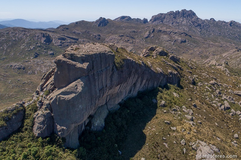
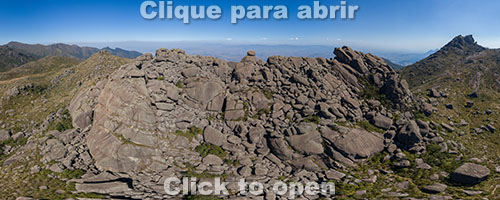
Prateleiras

360° image of Prateleiras, at 2,539 meters (8,330 feet)
Distance and elevation (round trip) from Posto Marcão (entrance): 12.6 km (7.8 mi) / 320 m (1,049 ft)
Great place for climbing and second most famous point of the Park, the summit of Prateleiras can be reached for rock climbers or using a trail that in some places require the use of the hands too, so hiring a guide is mandatory for those who are not climbers or are low experienced mountaineers. The view of the summit is not one of the most beautiful of the Park, but the way up to it is very fun.

Aerial photo of Prateleiras

Serra Fina and sunset seen from Prateleiras

Prateleiras seen from Pedra do Altar

Climbers at Prateleiras
Get to know the photo book "The Most Beautiful Trails of Patagonia"
Torres del Paine, El Chaltén, Bariloche, Ushuaia, Villarrica, Cerro Castillo, Dientes de Navarino and Parque Patagonia